PRODUCT DESCRIPTION
The software package is intended for operational processing of hydrological data and runoff prediction.ASSIMILATION OF ALL KINDS OF HYDROLOGICAL DATA
The package assimilates data from the Roshydromet unified database, including data from automatic gauging stations
CALCULATION OF RIVER RUNOFF AND WATER INFLOW TO RESERVOIRS
Algorithms for operational consideration of runoff according to the R 52.08.872-2018 document and calculation of the inflow to reservoirs are implemented
COMPATIBILITY WITH OTHER PROGRAMS AND DATA FORMATS
The package has an option of data import from the RIVERS-REGIME and some widely used formats, as well as an export of tables and graphs as reporting material
The software package for operational processing of hydrological data and runoff prediction
FUNCTIONALITY
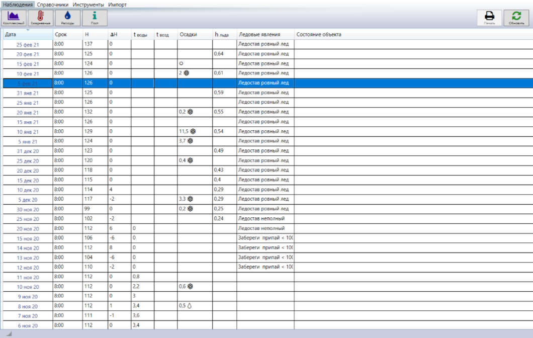
The package provides the whole range of actions for operational processing of hydrological data from their reception to the issue of calculation results
Automation
An intuitive approach and an automation at all stages of preparation and execution of calculations are combined with an option of flexible customization. It is possible to use the package both on one PC and in combination with a server.
Interface
User-friendly and thoughtful interface of the package makes the daily work of a hydrologist pleasant and effective
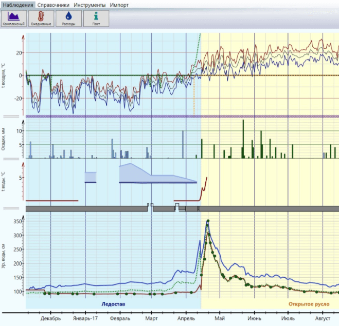
COMPLETE COMPOSITE GRAPH WITH MODERN ADAPTIVE DESIGN
Output of operational data in the form of a composite graph combines the traditional approach, the compliance with standards, and modern interface development technologies
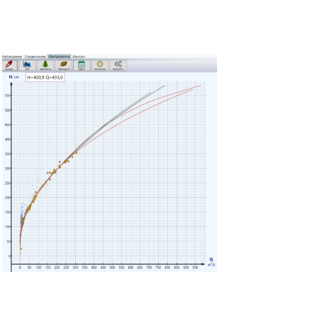
CALCULATION OF OPERATIONAL DISCHARGES USING Q = F(H) CURVES
The package implements the whole range of calculations of operational water discharge depending on the water body state in accordance to the R 52.08.872-2018 guidance document
CALCULATION OF INFLOW TO RESERVOIRS
The water inflow to reservoirs is computed using the inflow formulas and calculated operational discharges corrected for data updates
IMPORT AND EXPORT OF DATA IN MODERN FORMATS
Data for working with the package can be obtained from CSV, TXT and be entered manually, and the results of calculations and graphs can be exported to PDF or Excel
COMPATIBILITY WITH THE RIVERS-REGIME SYSTEM
Any data from the RIVERS-REGIME system, including gauging station passports, coordinates of rating curves, and observation data can be imported into the package in one move
FORMATION OF REPORTING TABLES AND SCREEN FORMS
Tables and graphs are formed in accordance with regulatory documents and are easily customized to specific needs
ASSIMILATION OF HIGH-FREQUENCY DATA FROM AUTOMATIC GAUGING STATIONS
The download of data directly from the Observation Data Collection Center and the time axis scaling allow an effective work with high-frequency water-level data from automatic gauging stations
SYSTEM OF TASKS FOR AUTOMATING DAILY WORK
All events are processed in the form of a list of routine or single tasks, which excludes random errors and calculation gaps
COMPATIBILITY WITH HYDROLOGIST WORKSTATION IN THE GISMETEO SYSTEM
If you have already worked with the Gismeteo system, hydrologist workstation databases are easily imported into GISMETEO.HYDRO